 |
Point-Pleasant
is a historic city located in Mason County, West Virginia at the confluence of the Ohio and Kanawha Rivers. As of the 2000 census, the population was 4,637 residents. Point Pleasant became well known for the 1967 collapse of the Silver Bridge, which killed 46 people. The town is also noted for the 1774 Battle of Point Pleasant, in which Virginia militiamen led by Colonel Andrew Lewis defeated an Algonquin Confederation of Shawnee and Mingo warriors led by Shawnee Chief Cornstalk. The event is celebrated in Point Pleasant as the first battle of the American Revolutionary War, and in 1908 the US Senate authorized erection of a monument to commemorate Point Pleasant as the site of the first battle of the American Revolution. Most historians, however, regard it not as a battle of the Revolution but instead as a part of Lord Dunmores War. It was the final home of Confederate Brigadier-General John McCausland, the next-to-last Confederate General to die. Point Pleasant is also known for its urban legend surrounding the Mothman. Paranormal enthusiasts flock to the city in search of the creature said to inhabit an abandoned TNT plant from World War II. It is believed that the Mothman is a harbinger of imminent disaster, and is now being seen around the world before great tragedies. A book by John A. Keel entitled The Mothman Prophecies was published in 1975 and a film inspired by the novel was released in 2002. There is also a Mothman Museum located in the town of Point Pleasant.

|
Point Pleasant Vacation Rentals
|

|
|
|
|
|
Point Pleasant Hotels and Resorts
|
|
|
| | | Hotels & Motels |
| Super 8 Motel | 321 Upper Riv Rd | Gallipolis, OH | 4.3 mi. | (740) 446-8080 | | Mason Motel | Rt 33 | Mason, WV | 13.6 mi. | (304) 773-9000 | | Best Rate Motel | | Ravenswood, WV | 21.5 mi. | (304) 273-3445 | | Scottish Inn | RR 2 Box 33 | Ravenswood, WV | 21.5 mi. | (304) 273-2830 | | Scottish Inn | PO Box 33 (silverton) | Ravenswood, WV | 21.5 mi. | (304) 273-2830 | | Holiday Inn Express | 1 Hospitality Dr | Ripley, WV | 22.1 mi. | (304) 372-5000 | | Best Western Inn | 701 Main St W | Ripley, WV | 22.5 mi. | (304) 372-9122 | | 77 Motor Inn | | Ripley, WV | 23.0 mi. | (304) 372-5949 | | Super 8 Motel | 102 Duke St | Ripley, WV | 23.0 mi. | (304) 372-8880 | | Simmons Motel | 812 S Penn Ave & 8TH St | Wellston, OH | 28.7 mi. | (740) 384-3230 | | Hampton Inn | 4190 State RT34 | Hurricane, WV | 29.2 mi. | (304) 760-7292 | | Holiday Inn Express | 4218 State Rt 34 | Hurricane, WV | 29.2 mi. | (304) 757-7177 | | Ramada Limited | 419 Hurricane CRK Rd | Hurricane, WV | 29.2 mi. | (304) 562-3346 | | Red Roof Inn | 500 Putnam Village Dr | Hurricane, WV | 29.2 mi. | (304) 757-6392 | | Days Inn Jackson | 972 E Main St | Jackson, OH | 29.5 mi. | (740) 286-3464 | | Days Inn Teays | Putnam Village Dr | Teays, WV | 29.6 mi. | (304) 729-3006 | | Comfort Inn | 605 E Main St | Jackson, OH | 29.9 mi. | (740) 286-7581 |

|
Point Pleasant Weather & Climate
|

|
|
|
Western West Virginia ,along the Ohio River, has a climate of four very distinct seasons. Warm summer temperatures tend to be in the 80s and cold winter temperatures tend to be in the 30s. The warmest month of the year is July with an average maximum temperature of 95F, while the coldest month of the year is January with an average minimum temperature of 22F. Temperature variations between night and day tend to be moderate during summer with a difference that can reach 21 F , and fairly limited during winter with an average difference of 18 F. The annual average precipitation in this region is 40.69 inches. Rainfall is fairly evenly distributed throughout the year. Snowfall can occur anytime from late November to March, with the most amounts falling during January and February.
�
|
| Month |
High Temp |
Low Temp |
Rainfall |
Ocean Temp |
| January |
39°F |
15°F |
3.74 in. |
- |
| February |
43°F |
16°F |
3.36 in. |
- |
| March |
54°F |
24°F |
4.27 in. |
- |
| April |
65°F |
31°F |
3.82 in. |
- |
| May |
75°F |
42°F |
4.86 in. |
- |
| June |
82°F |
51°F |
4.54 in. |
- |
| July |
86°F |
56°F |
5.37 in. |
- |
| August |
84°F |
55°F |
4.34 in. |
- |
| September |
78°F |
47°F |
3.74 in. |
- |
| October |
67°F |
35°F |
3.19 in. |
- |
| November |
54°F |
27°F |
3.92 in. |
- |
| December |
43°F |
21°F |
3.79 in. |
- |

|
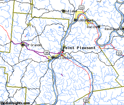
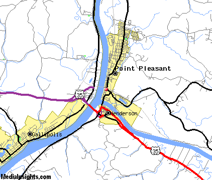
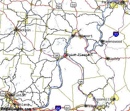
Point Pleasant Map & Transportation
|

|
|
 |
|
|
| Click each thumbnail image to enlarge. |
 |
|
 |
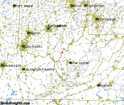 |
The closest airports in the area are Ohio University Snyder Field (UNI) located about 25 miles north of Point Pleasant in Athens / Albany, Ohio, the Ashland Boyd County airport (DWU) located approximately 38 miles southwest of Point Pleasant in Ashland, Kentucky, Tri State Milton J Ferguson Field (HTS) located roughly 40 miles southwest of Point Pleasant in Huntington, West Virginia, the Yeager airport (CRW) located around 43 miles southeast of Point Pleasant in Charleston, West Virginia, and finally the Mid Ohio Valley Regional airport (PKB) located about 50 miles northeast of Point Pleasant in Parkersburg, West Virginia.
|

|
Point Pleasant Attractions
|

|
|
| | | Amusement and Theme Parks |
| Camden Park | Huntington | WV | 33.8 mi. | |
| | | Water Parks |
| Wyandot Lake Amusement & Water Park | Powell | OH | 103.6 mi. | |
| | | Golf Courses |
| Hidden Valley Country Club | Point Pleasant | WV | | | | Cliffside Golf Club | Gallipolis | OH | 3.4 mi. | | | Riverside Golf Course | Mason | WV | 13.7 mi. | | | Oaks Golf Club | Lima | OH | 14.9 mi. | | | Springbrook Golf Club | Lima | OH | 14.9 mi. | | | Tamarac Golf Club | Lima | OH | 14.9 mi. | | | Greenhills Country Club | Ravenswood | WV | 21.3 mi. | | | Golf Course at Sycamore Creek | Ripley | WV | 23.1 mi. | | | Riviera Country Club | Lesage | WV | 25.2 mi. | | | Elm Golf Course | Athens | OH | 28.2 mi. | |
| | | Ski Areas |
| Canaan Valley | Davis | WV | 70.4 mi. | | | Winterplace | Flat Top | WV | 103.2 mi. | |
| | | State Parks |
| Tu-Endie-Wei State Park | | WV | 1.0 mi. | | | Forked Run State Park | | OH | 26.1 mi. | | | Lake Alma State Park | | OH | 28.6 mi. | | | Strouds Run State Park | | OH | 34.7 mi. | | | Lake Hope State Park | | OH | 35.4 mi. | | | Booker T Washington State Park | | WV | 38.6 mi. | |
| | | Museums |
| Museum of Radio and Technology | Huntington | WV | 33.8 mi. | (Technology) | | West Virginia State Museum | Charleston | WV | 43.7 mi. | (Multidisciplinary) |
| | | Zoos and Aquariums |
| The Wilds | Cumberland | OH | 74.2 mi. | | | Columbus Zoo | Columbus | OH | 89.8 mi. | | | Oglebay's Good Zoo | Wheeling | WV | 113.2 mi. | |
Notice a problem with the information on this page? Please notify us.
|
Disclaimer: We recommend you conduct your own research regarding all accomodations and attractions found on this website. The distances shown on this website are straight-line distances as the crow flies. The road distance may be considerably longer. You assume all liability for use of any information found on this website. No information is confirmed or warranted in any way. By using our services you agree to the terms and conditions of this disclaimer.
|
| We are the #1 site for your West Virginia Vacation presenting West Virginia vacation rentals, hotels, weather and map for each city. |
West Virginia Vacation .com
©1997-2025 All Rights Reserved.
|
|